
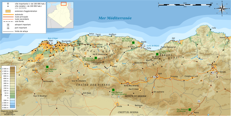
Archivo: Kabylie topographic map-fr

Descripción: Mapa topográfico en francès de Cabilia
Título: Kabylie topographic map-fr
Créditos: Création personnelle ; Topographie : NASA Shuttle Radar Topography Mission (SRTM3 v.2) (domaine public) ;Bathymétrie : ETOPO1 de la National Geophysisal Data Center ;River, coast, lakes, places, transportation, boundaries / Cours d'eau, côtes, récifs, extension d'agglomération et villes, transports, frontières : données de la carte © les contributeurs d'OpenStreetMap, CC-BY-SA Openstreetmap ;Urban area : NaturalEarth ;Locator map / Carte de situation dérivée de File:Algeria location map.svgOthers sources / sources diverses (pour certains noms) : le petit futé Algérie 2011, carte pp. 288-289.Other symbols / autres symboles provenant de File:Maps template-fr.svgSoftware / logiciels utilisés (méthode décrite dans ce didacticiel) : Visualization software 3DEM ; Quantum GIS ; The Gimp ; Inkscape ;
Autor(a): © Bourrichon (talk) - fr:Bourrichon
Permiso: Attribution and Share-Alike required Any use of this image can be made as long as you credit me (Wikimedia Commons user: Bourrichon) as the author and distribute the copies and derivative works under the same license(s) that the one(s) stated below. A message with a reply address would also be greatly appreciated.
Términos de Uso: Creative Commons Attribution-Share Alike 3.0
Licencia: CC BY-SA 3.0
Enlace de Licencia: https://creativecommons.org/licenses/by-sa/3.0
¿Se exige la atribución?: Sí
Usos del archivo
La siguiente página enlaza a este archivo:
