
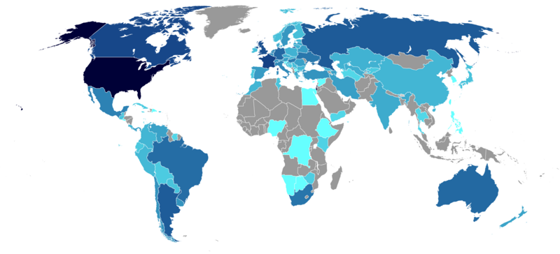
Archivo: Jewish Population by Country (2013)

Tamaño de esta previsualización: 800 × 364 píxeles. Otras resoluciones: 320 × 146 píxeles | 1800 × 820 píxeles.
Archivo original (1800 × 820 píxeles; tamaño de archivo: 75 KB; tipo MIME: image/png)
Descripción: The image illustrates a map with the number of Jews by country shaded in blue.
Título: Jewish Population by Country (2013)
Créditos: Este mapa fue creado con GunnMap GunnMap was created by Arthur Gunn and is available, free, at http://gunn.co.nz/map/ and http://gunnmap.herokuapp.com/. Please attribute by linking to http://gunn.co.nz/map/.
Autor(a): Halma10
Términos de Uso: Creative Commons Attribution-Share Alike 3.0
Licencia: CC BY-SA 3.0
Enlace de Licencia: https://creativecommons.org/licenses/by-sa/3.0
¿Se exige la atribución?: Sí
Usos del archivo
Las siguientes páginas enlazan a este archivo:
.png&oldid=4533560)

Todo el contenido de los artículos de la Enciclopedia Kiddle (incluidas las imágenes) se puede utilizar libremente para fines personales y educativos bajo la licencia Atribución-CompartirIgual a menos que se indique lo contrario.
.png)