
Archivo: Is-wb-gs-gh v3

Tamaño de esta previsualización: 374 × 600 píxeles. Otras resoluciones: 150 × 240 píxeles | 1428 × 2289 píxeles.
Archivo original (1428 × 2289 píxeles; tamaño de archivo: 259 KB; tipo MIME: image/png)
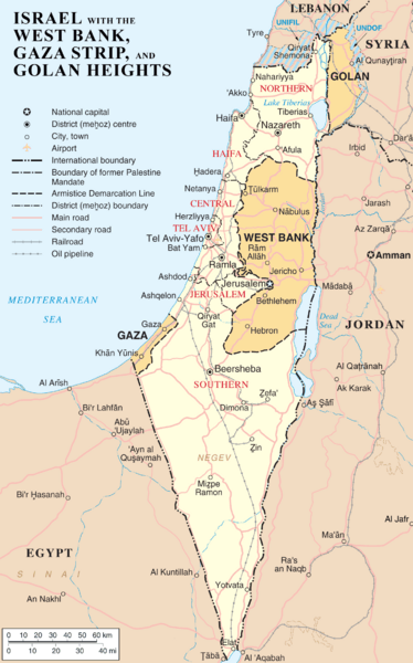
Description: Map of Israel, the Palestinian territories (West Bank and Gaza Strip), the Golan Heights, and portions of neighbouring countries. Also United Nations deployment areas in countries adjoining Israel or Israeli-held territory, as of January 2004.
Title: Is-wb-gs-gh v3
Credit: Transferred from en.wikipedia to Commons. (Original text: http://www.un.org/Depts/Cartographic/map/profile/israel.pdf (heavily modified))
Author: =The original uploader was ChrisO at English Wikipedia (Original text: en:User:ChrisO)
Usage Terms: Public domain
License: Public domain
Attribution Required?: No
Usos del archivo
La siguiente página enlaza a este archivo:

Todo el contenido de los artículos de la Enciclopedia Kiddle (incluidas las imágenes) se puede utilizar libremente para fines personales y educativos bajo la licencia Atribución-CompartirIgual a menos que se indique lo contrario.