
Archivo: Ioke 2006-09-04 0320Z

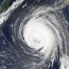
Descripción: Tropical Storm Ioke looks more like a worn-out typhoon than a tropical storm in satellite imagery obtained on September 4, 2006. Appearances do not deceive in this instance. Ioke started as all tropical cyclones do, as a depression—an area of low atmospheric pressure. After forming August 19, 2006, the depression quickly developed into a tropical storm, the threshold for earning a name. Ioke rose all the way to hurricane strength in less than 24 hours. Ioke has since also performed another unusual trick, crossing the International Date Line on August 27, which by convention means the tropical cyclone is called a typhoon instead of a hurricane. Technically, it became a super typhoon (a term used for typhoons with sustained winds over 240 kilometers per hour (150 miles per hour)) on August 24, but retained the title of hurricane until it crossed into the typhoon region. With warm seas under it, little wind shear to tear it apart, and no significant land in its way, Super Typhoon Ioke managed to traverse most of the world’s largest ocean, only gradually running down as it approached Japan, thousands of kilometers from its formation point. This photo-like image was acquired by the Moderate Resolution Imaging Spectroradiometer (MODIS) on the Aqua satellite on September 4, 2006, at 1:20 p.m. local time (03:20 UTC). Tropical Storm Ioke at the time of this image had a well-defined round shape, distinct spiral-arm structure, and a cloud-filled (or “closed”) eye. The University of Hawaii’s Tropical Storm Information Center reported that Ioke had sustained winds of around 130 kilometers per hour (80 miles per hour) at the time this satellite image was acquired, enough to still be classified as a typhoon. Within hours, however, central winds continued to weaken, and the former super typhoon was reclassified as a tropical storm. Though it appears to be approaching Japan in this satellite image, the track of the storm was curving away from its long westbound track and was heading north. It was predicted to eventually move east at higher latitudes without affecting Japan.
Título: Ioke 2006-09-04 0320Z
Créditos: http://earthobservatory.nasa.gov/NaturalHazards/natural_hazards_v2.php3?img_id=13833
Autor(a): NASA image created by Jesse Allen, Earth Observatory, using data obtained courtesy of the MODIS Rapid Response team.
Permiso: Public domainPublic domainfalsefalse Este archivo es de dominio público porque fue creado por la NASA. Las políticas sobre copyright de la NASA estipulan que «el material de la NASA no está protegido con copyright a menos que se indique lo contrario». (Políticas sobre copyright de la NASA o Políticas sobre la utilización de imágenes del Jet Propulsion Laboratory). Advertencias: El uso del logotipo de la NASA (incluidos el logotipo actual y los anteriores) está restringido. El sitio web de la NASA almacena una gran cantidad de imágenes del Programa Espacial de la URSS, de la Agencia Espacial Federal Rusa y otras agencias espaciales no estadounidenses. Estas imágenes no son de dominio público. Material del Telescopio espacial Hubble puede tener copyright si no proviene explícitamente del Space Telescope Science Institute. [1] Todo el material creado por la sonda espacial SOHO está protegido por copyright y requiere permiso para ser utilizado con fines comerciales o no educativos. [2] Las imágenes que figuran en el sitio web Astronomy Picture of the Day (APOD) pueden tener copyright. [3]
Términos de Uso: Dominio Público
Licencia: Dominio Público
¿Se exige la atribución?: No
Usos del archivo
La siguiente página enlaza a este archivo:
