
Archivo: Hurricane Harvey ESA382898

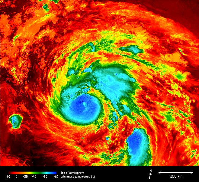
Description: The Copernicus Sentinel-3A satellite saw the temperature at the top of Hurricane Harvey on 25 August 2017 at 04:06 GMT as the storm approached the US state of Texas. The brightness temperature of the clouds at the top of the storm, some 12–15 km above the ocean, range from about –80°C near the eye of the storm to about 20°C at the edges. Hurricanes are one of the forces of nature that can be tracked only by satellites, providing up-to-date imagery so that authorities know when to take precautionary measures. Satellites deliver information on a storm’s extent, wind speed and path, and on key features such as cloud thickness, temperature, and water and ice content. Sentinel-3’s Sea and Land Surface Temperature Radiometer measures energy radiating from Earth’s surface in nine spectral bands and two viewing angles.
Title: Hurricane Harvey ESA382898
Credit: http://www.esa.int/spaceinimages/Images/2017/08/Hurricane_Harvey
Author: European Space Agency
Permission: contains modified Copernicus Sentinel data (2017), processed by ESA,CC BY-SA 3.0 IGO
Usage Terms: Creative Commons Attribution-Share Alike 3.0 igo
License: CC BY-SA 3.0 igo
License Link: https://creativecommons.org/licenses/by-sa/3.0/igo/deed.en
Attribution Required?: Yes
Usos del archivo
La siguiente página enlaza a este archivo:
