
Archivo: Hurricane Adrian May 19 915

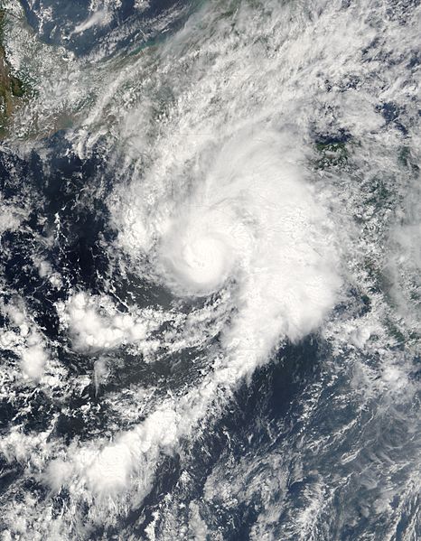
Descripción: Hurricane Adrian was zeroing in on the Pacific coast of El Salvador and Guatemala when the Moderate Resolution Imaging Spectroradiometer (MODIS) on NASA's Terra satellite captured this image on May 19, 2005, at 10:45 a.m., Pacific Daylight Time. This highly unusual storm is the first of the 2005 Pacific hurricane season, having formed on May 17, just two days after the season officially started. The storm intensified over a pocket of warm water and moved east toward Guatemala and El Salvador. Adrian reached hurricane status about the time this image was acquired. Hurricane Adrian is unusual not because of its strength - it's actually a weak storm� or because of its timing, though no tropical storm has ever struck Central America this early in May; rather, Adrian is rare because of its path. Most hurricanes that form in the Pacific head north into Mexico or west to dissipate over the ocean. Adrian moved east. Since 1966, only four cyclones have made landfall over Guatemala or El Salvador, and Adrian's current path will make it the fifth. The outer bands of clouds were already over land when MODIS captured this image. The biggest threat that Adrian poses to Central America is from the heavy rain it may dump on the region. Rugged mountains stretch across El Salvador, Guatemala, and Honduras, and heavy rain could trigger flash floods and mudslides. If Adrian survives its encounter with the mountains of Central America, it could emerge as a tropical system in the Caribbean. Occasionally, storms will cross from the Atlantic into the Pacific, but it is rare for a storm to move from the Pacific into the Atlantic, as Adrian could. The large version of this image has a resolution of 250 meters per pixel. The image is available in additional resolutions from the MODIS Rapid Response Team.
Título: Hurricane Adrian May 19 915
Créditos: http://earthobservatory.nasa.gov/NaturalHazards/natural_hazards_v2.php3?img_id=12879
Autor(a): Image courtesy Jeff Schmaltz, MODIS Land Rapid Response Team at NASA GSFC
Permiso: Public domainPublic domainfalsefalse Este archivo es de dominio público porque fue creado por la NASA. Las políticas sobre copyright de la NASA estipulan que «el material de la NASA no está protegido con copyright a menos que se indique lo contrario». (Políticas sobre copyright de la NASA o Políticas sobre la utilización de imágenes del Jet Propulsion Laboratory). Advertencias: El uso del logotipo de la NASA (incluidos el logotipo actual y los anteriores) está restringido. El sitio web de la NASA almacena una gran cantidad de imágenes del Programa Espacial de la URSS, de la Agencia Espacial Federal Rusa y otras agencias espaciales no estadounidenses. Estas imágenes no son de dominio público. Material del Telescopio espacial Hubble puede tener copyright si no proviene explícitamente del Space Telescope Science Institute. [1] Todo el material creado por la sonda espacial SOHO está protegido por copyright y requiere permiso para ser utilizado con fines comerciales o no educativos. [2] Las imágenes que figuran en el sitio web Astronomy Picture of the Day (APOD) pueden tener copyright. [3]
Términos de Uso: Dominio Público
Licencia: Dominio Público
¿Se exige la atribución?: No
Usos del archivo
Las siguientes páginas enlazan a este archivo:
