
Archivo: Historical Europe-Asia boundaries 1700 to 1900
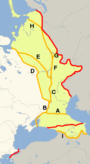
Descripción: The factual accuracy of this map or the file name is disputed. Please see: https://commons.wikimedia.org/wiki/File_talk:Historical_Europe-Asia_boundaries_1700_to_1900.png Historical conventions for the boundary between Europe and Asia, from maps published between 1700 and 1920 (note that maps from before the late 16th century cannot show a clear delineation for the northern part of the boundary, as the Arctic Ocean (Nova Zemlya, Sea of Kara etc.) was not known to cartographers). Europe Asia Territory which has historically been placed in either Europe or Asia the red line shows the modern convention following the crest of the Greater Caucasus, the Ural River, and the Urals range. This has been the mainstream convention since about 1850, illustrated by e.g. Johnson (1861). Line A shows an alternative modern convention illustrated e.g. by Beach and McMurry (1914). The convention follows the Don and Manych Rivers, placing the Russian Caucasus Viceroyalty in Asia. line B follows the Don River until Volgograd (continued under D or C, depending on convention) line C follows the Volga from Volgograd until Samara, continued under E or F depending on convention line D follows the Don past Volgograd, cutting north overland to Archangelsk staying west of the Volga. This convention is found in the first official atlas of the Russian Empire, published in 1745. line E follows the Volga until the Samara bend, and then cuts northwest to the Northern Dvina, ending at Archangelsk. This convention is used by Christoph Weigel in his Asia Vetus map, published 1719. line F leaves the Volga at the Samara bend, cutting to the lower Irtysh and the Ob River. Used by Johann Baptist Homann in his Recentissima Asiae Delineatio, published 1730. lines G and H: John Cary in his New Map of Asia (1806) follows the Don and the Volga (B, C, F), but then cuts across to the Urals south of Perm (G) and leaves the Ural watershed, reaching the coast of the Arctic Ocean west of the Yugorsky Peninsula (H) line I: follows the river Aras in the east and the former Ottoman-Russian border in the west, as depicted on this 1874 map.
Título: Historical Europe-Asia boundaries 1700 to 1900
Créditos: Europe_polar_stereographic_Caucasus_Urals_boundary.svg
Autor(a): Europe_polar_stereographic_Caucasus_Urals_boundary.svg: *Blank_map_of_Europe_(polar_stereographic_projection)_cropped.svg: Ssolbergj derivative work: Dbachmann (talk) derivative work: Dbachmann (talk)
Términos de Uso: Creative Commons Attribution-Share Alike 3.0
Licencia: CC BY-SA 3.0
Enlace de Licencia: https://creativecommons.org/licenses/by-sa/3.0
¿Se exige la atribución?: Sí
Usos del archivo
La siguiente página enlaza a este archivo:
