
Archivo: Hinnamnor 2022-09-01 0000Z
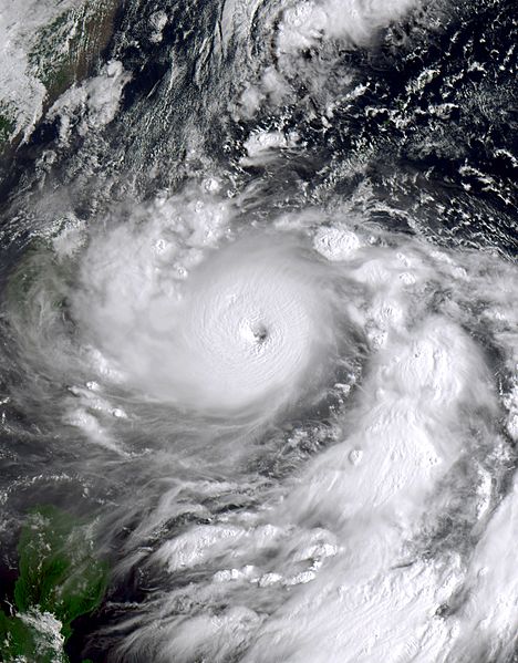
Descripción: This true-color image of Typhoon Hinnamnor (Locally known in the Philippines as "Henry") was captured on the morning of September 1, 2022, at 0:00 UTC or (8:00 AM Taiwan Local Time), by the Advanced Himawari Imager (AHI) instrument flying aboard JMA's Himawari 8 satellite. Hinnamnor was a compact and powerful typhoon that originated from a tropical disturbance northeast of the Marshall Islands during the 2022 Pacific typhoon season in late August 2022. When this image was captured, Hinnamnor had already passed through the Okinawa Islands and was just east of Taiwan while entering PAGASA's area of responsibility. Hinnamnor would impact Korean Peninsula later in its track and turn extratropical and impact Eastern Russia while going through the Sea of Japan. When this was captured, Hinnamnor was at its secondary peak intensity as a Category 5 equivalent typhoon, with winds of 160 mph (260 km/h) (140 knots) on the 1-min Saffir-Simpson scale and winds of 120 mph (190 km/h) on the 10-min JMA typhoon scale making it a "violent typhoon" on that scale, also when this image was taken it had a minimum central pressure of 920 mbar (27.2 inHg).
Título: Hinnamnor 2022-09-01 0000Z
Créditos: https://re.ssec.wisc.edu
Autor(a): University of Wisconsin-Madison, Space Science and Engineering Center
Licencia: Attribution
Usos del archivo
Las siguientes páginas enlazan a este archivo:
