
Archivo: Halley compass variations 1702
Tamaño de esta previsualización: 481 × 599 píxeles. Otras resoluciones: 193 × 240 píxeles | 642 × 800 píxeles.
Archivo original (642 × 800 píxeles; tamaño de archivo: 150 KB; tipo MIME: image/jpeg)
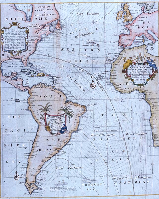
Description: Edmond Halley's New and Correct Chart Shewing the Variations of the Compass (1701), the first chart to show lines of equal magnetic variation. See also exhibit G201:1/1 at the UK National Maritime Museum. The NMM scan may however be protected by copyright in the UK.
Title: Halley compass variations 1702
Credit: Plate 22 from Mount & Page's 1702 "Atlas Maritimus Novus, or the New Sea-Atlas." This image was found at [1], in the online map database of the Louisiana State Museum, accession number 1982.077.020
Author: Edmond Halley
Usage Terms: Public domain
License: Public domain
Attribution Required?: No
Usos del archivo
La siguiente página enlaza a este archivo:

Todo el contenido de los artículos de la Enciclopedia Kiddle (incluidas las imágenes) se puede utilizar libremente para fines personales y educativos bajo la licencia Atribución-CompartirIgual a menos que se indique lo contrario.