
Archivo: Hadrian's Wall map

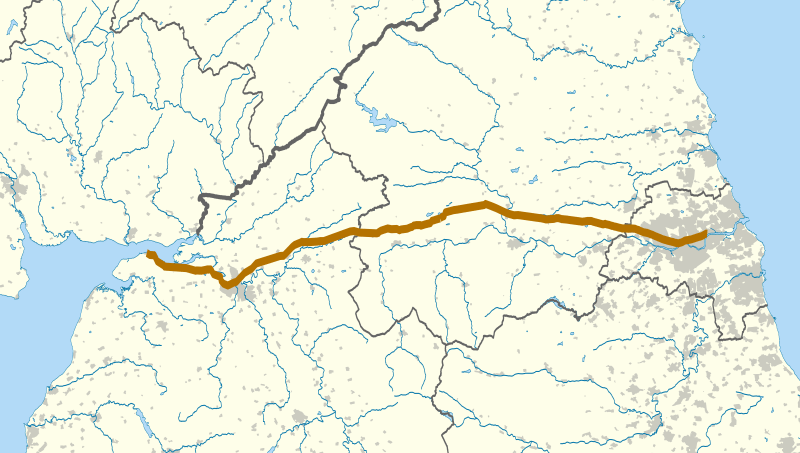
Description: The route of Hadrian's Wall (in brown) in northern England. The background map shows modern counties and urban areas. Equirectangular map projection on WGS 84 datum, with N/S stretched 170% Geographic limits: West: 3.65W East: 1.25W North: 55.4N South: 54.6N
Title: Hadrian's Wall map
Credit: Ordnance Survey OpenData. Administrative borders and coastline data from Boundary-Line product. Rivers, lakes and urban area data from Meridian 2 product. Hadrian's Wall from Strategi product.
Author: Nilfanion
Permission: This file is licensed under the Creative Commons Attribution-Share Alike 3.0 Unported license. You are free: to share – to copy, distribute and transmit the work to remix – to adapt the work Under the following conditions: attribution – You must attribute the work in the manner specified by the author or licensor (but not in any way that suggests that they endorse you or your use of the work). share alike – If you alter, transform, or build upon this work, you may distribute the resulting work only under the same or similar license to this one. http://creativecommons.org/licenses/by-sa/3.0 CC BY-SA 3.0 Creative Commons Attribution-Share Alike 3.0 truetrue
Usage Terms: Creative Commons Attribution-Share Alike 3.0
License: CC BY-SA 3.0
License Link: http://creativecommons.org/licenses/by-sa/3.0
Attribution Required?: Yes
Usos del archivo
La siguiente página enlaza a este archivo:
