
Archivo: GrandNP

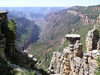
Descripción: (photo synopsis)-View down-canyon/down-stream, of upper reaches of Phantom Canyon watershed. Tiyo Point is right (west) on ridgeline (out-of-view); lower elevation The Colonnade, is at left and when viewed from the South Rim, what is viewed is The Colonnade terminus, seen as an approximate rectangle-shape. (Viewed at left, Manu Temple & Brahma Temple. Viewed at end of this Phantom Canyon reach, Isis Temple, Arizona.) View of Grand Canyon from Tiyo Point - looking SSW-(almost due-south, down The Colonade). (Tiyo Point is at photo right, over ridgeline)--The canyon, The Colonnade, is a west drainage into Phantom Creek (3 canyons at headwaters, 2 are east and west of Tiyo Point). The ridgeline right continues to Shiva Temple-(unseen in photo), (a Plateau, en:tepui-like, flat landform), and the small prominence down the canyon is Isis Temple.
Título: GrandNP
Créditos: Trabajo propio
Autor(a): Scott Catron
Términos de Uso: Creative Commons Attribution 2.5
Licencia: CC BY 2.5
Enlace de Licencia: https://creativecommons.org/licenses/by/2.5
¿Se exige la atribución?: Sí
Usos del archivo
Las siguientes páginas enlazan a este archivo:
