
Archivo: Gilman (United States (after the Treaty of Guadalupe Hidalgo)) 1848 UTA
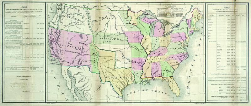
Descripción: By the Treaty of Guadalupe Hidalgo at the end of the U.S. War with Mexico in 1848, the United States received the former Mexican territories of Upper California and New Mexico and confirmed its claim to Texas. This map from President Polk's printed review of the year shows new and old boundaries, noting when and by which treaties these were established. The southwestern boundary, stretching west from El Paso, would prove a difficult problem in the coming years, established as it was during the treaty negotiations between the U.S. and Mexican diplomats on the basis of different editions of a faulty map – the Disturnell map of Mexico of 1847. The table at left documents the total estimated square miles, acreage, and miles of coastline acquired as well as the previously existing statistics for the nation and its various territories. Ominously, the table at right explains the square mileage and acreage of both the free and slave states and territories, documenting a critical area of contention that would ultimately lead to civil war.
Título: [United States (after the Treaty of Guadalupe Hidalgo)]
Créditos: UTA Libraries Cartographic Connections: map / texto
Autor(a): E. Gilman
Términos de Uso: Dominio Público
Licencia: Dominio Público
¿Se exige la atribución?: No
Usos del archivo
No hay páginas que enlacen a esta imagen.
)_1848_UTA.jpg&oldid=3428918)

)_1848_UTA.jpg)