
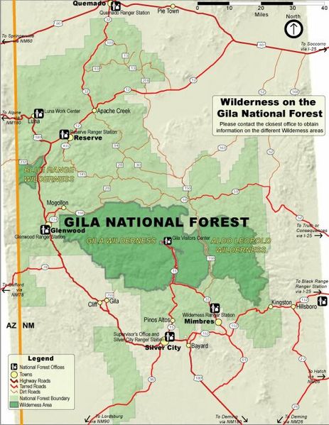
Archivo: Gila NF Wilderness Map

Tamaño de esta previsualización: 463 × 599 píxeles. Otras resoluciones: 185 × 240 píxeles | 541 × 700 píxeles.
Archivo original (541 × 700 píxeles; tamaño de archivo: 83 KB; tipo MIME: image/jpeg)
Description: Map of the Gila National Forest (light green), with designated wilderness areas (dark green) — located in southwestern New Mexico. Includes the large Gila Wilderness area, in the Mogollon Mountains.
Title: Gila NF Wilderness Map
Credit: US Forest Service[1]
Author: USFS
Permission: Public domainPublic domainfalsefalse This image is a work of the Forest Service of the United States Department of Agriculture. As a work of the U.S. federal government, the image is in the public domain.
Usage Terms: Public domain
License: Public domain
Attribution Required?: No
Usos del archivo
Las siguientes páginas enlazan a este archivo:

Todo el contenido de los artículos de la Enciclopedia Kiddle (incluidas las imágenes) se puede utilizar libremente para fines personales y educativos bajo la licencia Atribución-CompartirIgual a menos que se indique lo contrario.