
Archivo: Germany occupation zones with border

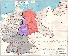
Description: Map of the occupation zones of Germany in 1945, modified to show the inner German border and the zone from which Allied forces withdrew in July 1945. From Earl F. Ziemke, The U.S. Army in the Occupation of Germany, 1975. Library of Congress, Catalog Card Number 75-619027. Explanation taken from w:Inner_German_border: The Allied zones of occupation in post-war Germany, highlighting the Soviet zone (red), the inner German border (heavy black line) and the zone from which British and American troops withdrew in July 1945 (purple). The provincial boundaries are those of pre-Nazi Weimar Germany, before the present Länder (federal states) were established.
Title: Germany occupation zones with border
Credit: Modified version of http://www.globalsecurity.org/military/library/report/other/us-army_germany_1944-46_map3.htm
Author: US Army
Usage Terms: Public domain
License: Public domain
Attribution Required?: No
Usos del archivo
La siguiente página enlaza a este archivo:
