
Archivo: Germanwings Flight 9525 flight path topographic vector-es

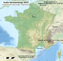
Descripción: Trayectoria de Vuelo 9525 de Germanwings (Español).
Título: Germanwings Flight 9525 flight path topographic vector-es
Créditos: Trabajo propio Flight path based on data from Flightradar24, specifically the page for D-AIPX (only accessible for a limited time). Copyright cannot be claimed on factual information. The data used for this map is factual information: the location of the aircraft. Nonetheless, Flightradar24 is credited as the source of the information. Background map: File:France relief location map.jpg
Autor(a): AHeneen. Background map: Eric Gaba (Sting)
Términos de Uso: Creative Commons Attribution-Share Alike 4.0
Licencia: CC BY-SA 4.0
Enlace de Licencia: https://creativecommons.org/licenses/by-sa/4.0
¿Se exige la atribución?: Sí
Usos del archivo
La siguiente página enlaza a este archivo:
