
Archivo: German Confederation 1815

Tamaño de esta previsualización PNG del archivo SVG: 450 × 456 píxeles. Otra resolución: 237 × 240 píxeles.
Archivo original (archivo SVG, nominalmente 450 × 456 píxeles, tamaño de archivo: 813 KB)
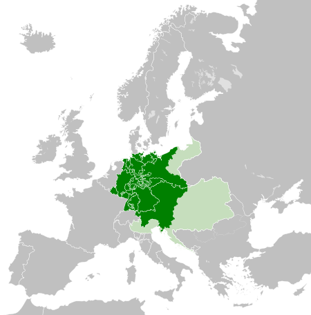
Descripción: Map of the German Confederation, circa 1815, following the Congress of Vienna. The protectorate and the other States in personal union of the Austrian Empire not within the confederation is shown in light green (but Western Prussia is a mistake). Member states
Título: German Confederation 1815
Créditos: Este archivo deriva de: Blank map of Europe.svg:
Autor(a): Blank_map_of_Europe.svg: maix¿? derivative work: Alphathon /'æɫfə.θɒn/ (talk)
Términos de Uso: Creative Commons Attribution-Share Alike 3.0
Licencia: CC BY-SA 3.0
Enlace de Licencia: https://creativecommons.org/licenses/by-sa/3.0
¿Se exige la atribución?: Sí
Usos del archivo
La siguiente página enlaza a este archivo:

Todo el contenido de los artículos de la Enciclopedia Kiddle (incluidas las imágenes) se puede utilizar libremente para fines personales y educativos bajo la licencia Atribución-CompartirIgual a menos que se indique lo contrario.