
Archivo: France départementale

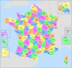
Descripción: Administrative map of France, created under Inkscape 0.47 from several of the excellent maps (especially this one) created by Sting: thanks (and congrats) to him. The file consists of twenty-four layers: Frame, Administrative Centres of Regions, Towns, Administrative Centres of Departments, Numbers of Departments, Names of Regions, Names of Departments, **Overseas Departements Insets, **Paris Conurbation Inset, Coordinates, Scale and Mini-map, International boundaries, Coasts, Regional boundaries, Departmental boundaries, Lakes, Rivers, *Metropolitan Regions, *Metropolitan Departments, French lands, Foreign lands, Seas and Oceans, Altimetric Scale, Topography. Visible Layer Hidden Layer The asterisk indicates a layer with sublayers The double asterisk indicates a layer with sublayers, some of which have sublayers
Título: France départementale
Créditos: Trabajo propio
Autor(a): Nilstilar
Términos de Uso: Creative Commons Attribution-Share Alike 4.0
Licencia: CC BY-SA 4.0
Enlace de Licencia: https://creativecommons.org/licenses/by-sa/4.0
¿Se exige la atribución?: Sí
Usos del archivo
La siguiente página enlaza a este archivo:
