
Archivo: Exodus Map
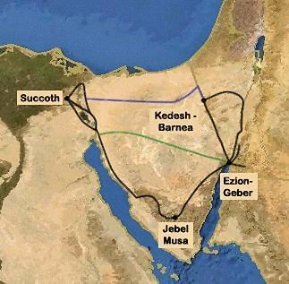
Descripción: Exodus Map c. 14th century BCE. The map shows the standard 3 alternative possible routes for the first part of the Israelite exodus. The inclusion of Jebel Musa is a very recent tradition. The "Sinai peninsula" has only had that name since Christian times. Modern archeologists contest the existence of a mass exodus altogether (see Finkelstein and Silberman, the bible unearthed, The free press, New-York, 2001)
Título: Exodus Map
Créditos: Map generated based on image from: http://www.planiglobe.com Routes drawn by ThaThinker Esta es una imagen retocada, lo que significa que ha sido alterada digitalmente de su versión original. Modificaciones: Brightness/contrast, clarify, remove some jpg artifacts.
Autor(a): This map has been uploaded by Electionworld from en.wikipedia.org to enable the Wikimedia Atlas of the World . Original uploader to en.wikipedia.org was ThaThinker, known as ThaThinker at en.wikipedia.org. Electionworld is not the creator of this map. Licensing information is below.
Términos de Uso: Creative Commons Attribution 2.5
Licencia: CC BY 2.5
Enlace de Licencia: https://creativecommons.org/licenses/by/2.5
¿Se exige la atribución?: Sí
Usos del archivo
La siguiente página enlaza a este archivo:
