
Archivo: EAfrica
No disponible en mayor resolución.
EAfrica.png (454 × 382 píxeles; tamaño de archivo: 42 KB; tipo MIME: image/png)
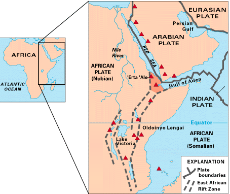
Description: Map of East Africa showing some of the historically active volcanoes(red triangles) and the Afar Triangle (shaded, center) -- a so-called triple junction (or triple point), where three plates are pulling away from one another: the Arabian Plate, and the two parts of the African Plate (the Nubian and the Somalian) splitting along the East African Rift Zone.
Title: EAfrica
Credit: http://pubs.usgs.gov/gip/dynamic/East_Africa.html
Author: USGS
Usage Terms: Public domain
License: Public domain
Attribution Required?: No
Usos del archivo
El siguiente archivo es un duplicado de éste (más detalles):
No hay páginas que enlacen a esta imagen.

Todo el contenido de los artículos de la Enciclopedia Kiddle (incluidas las imágenes) se puede utilizar libremente para fines personales y educativos bajo la licencia Atribución-CompartirIgual a menos que se indique lo contrario.