
Archivo: Disturnell & Schroeter Map Illustrating the Disputed Boundary Between the United States and Mexico 1853 UTA
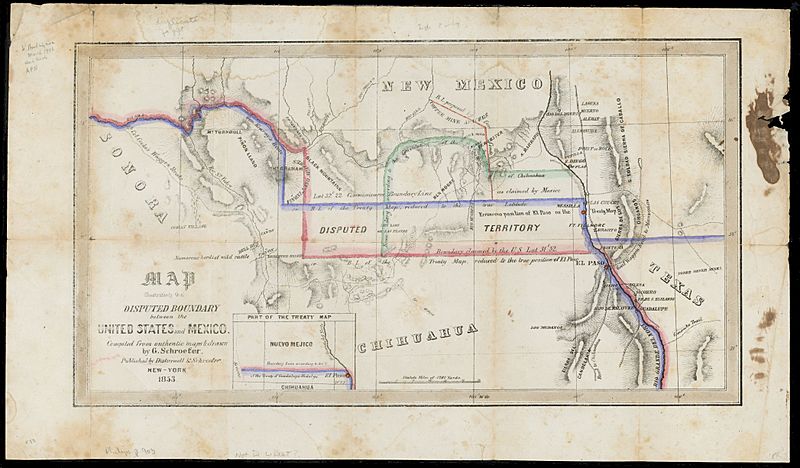
Descripción: Soon after the U.S. and Mexican Boundary Commissions began their surveys in 1849, they noted glaring errors on the 1847 map that had been used to negotiate the Treaty of Guadalupe Hidalgo. The town of El Paso, and thus the boundary itself, had been situated too far to the north on the map, resulting in disagreements between the United States and Mexican governments over exactly where the boundary should be. The New York publisher of the original treaty map, John Disturnell, later issued this map to correct the earlier errors and to illustrate the disputed boundary lines that had resulted (the red for the U.S. claim and the blue for Mexico's). Also, as shown, Americans had learned that even with the corrections in latitude, one of the best routes to California – Cooke's Wagon Road – actually lay south of the new border, and a large lobby of U.S. citizens wanted the land to construct a railroad from El Paso to the Pacific. Given the Mexican government's need for cash, on December 30, 1853, U.S. and Mexican diplomats signed the Gadsden Purchase treaty, whereby the United States paid Mexico $10 million for 29,142,400 acres of a wedge of land within the present states of New Mexico and Arizona.
Título: Map illustrating the Disputed Boundary between the United States and Mexico
Créditos: UTA Libraries Cartographic Connections: map / texto
Autor(a): John Disturnell
Términos de Uso: Dominio Público
Licencia: Dominio Público
¿Se exige la atribución?: No
Usos del archivo
La siguiente página enlaza a este archivo:
