
Archivo: Dioecesis Asiana 400 AD
No disponible en mayor resolución.
Dioecesis_Asiana_400_AD.png (609 × 392 píxeles; tamaño de archivo: 249 KB; tipo MIME: image/png)
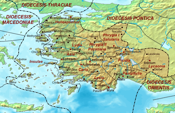
Description: Map of the Diocese of Asia (Dioecesis Asiana) ca. 400 AD, showing the subordinate provinces and the major cities.
Title: Dioecesis Asiana 400 AD
Credit: Base map found at en:Topographic map#Global 1-kilometer map, otherwise self-made. Data based on maps in atlases and the internet and on contemporary sources, primarily the Notitia Dignitatum and the Synecdemus. Note: the exact course of the provincial boundaries is very uncertain and in many cases only approximate.
Author: Cplakidas
Usage Terms: Public domain
License: Public domain
Attribution Required?: No
Usos del archivo
La siguiente página enlaza a este archivo:

Todo el contenido de los artículos de la Enciclopedia Kiddle (incluidas las imágenes) se puede utilizar libremente para fines personales y educativos bajo la licencia Atribución-CompartirIgual a menos que se indique lo contrario.