
Archivo: Dardanelles defences 1915-es

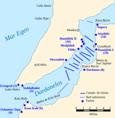
Descripción: Map of the Dardanelles defences in February and March, 1915. The original lines of naval mines are numbered 1 to 10. The 11th line, laid in Erin Keui Bay by the minelayer Nusrat on 8 March, is numbered 11. The anti-submarine nets are shown as dotted lines. Major forts are indicated with blue boxes and the Turkish name and equivalent British number for the fort is given, if known. Based on a maps from: A Short Military History of World War I - Atlas, edited by T. Dodson Stamps and Vincent J. Esposito, 1950 Gallipoli: A Battlefield Guide, Phil Taylor & Pam Cupper, 1989 Gallipoli, Les Carlyon, 2001.
Título: Dardanelles defences 1915-es
Créditos: Esta imagen ha sido extraída del archivo
Autor(a): Gsl
Términos de Uso: Dominio Público
Licencia: Dominio Público
¿Se exige la atribución?: No
Usos del archivo
La siguiente página enlaza a este archivo:
