
Archivo: Crete archaeological sites-fr

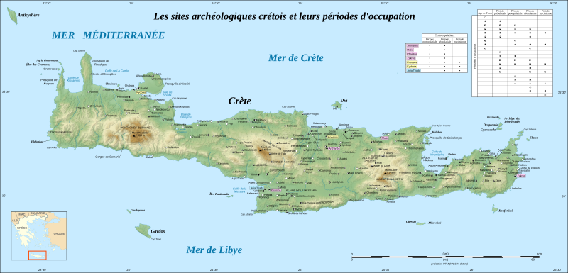
Descripción: Map of the Cretan archaeological sites and their occupation periods. Note: the background map is a raster image embedded in the SVG file.
Título: Crete archaeological sites-fr
Créditos: Own work ; Topographic background map : NASA Shuttle Radar Topography Mission (SRTM3 v.2) (public domain) edited with 3DEM; Localization of the sites provided by fr:Aeleftherios; References used for the placement of the sites : Sfakia-Crete map and Castello Hotels map; Locator map : Image:Map_Greece_expansion_1832-1947-fr.svg (modified) created by Historicair; Translation of the Greek names into French : fr:Cédric Boissière and fr:Aeleftherios
Autor(a): Eric Gaba (Sting - fr:Sting)
Permiso: Attribution and Share-Alike required Any use of this map can be made as long as you credit me (Eric Gaba – Wikimedia Commons user: Sting) as the author, User:Historicair for the locator map, and distribute the copies and derivative works under the same license(s) that the one(s) stated below. A message with a reply address would also be greatly appreciated.
Términos de Uso: Creative Commons Attribution-Share Alike 4.0
Licencia: CC BY-SA 4.0
Enlace de Licencia: https://creativecommons.org/licenses/by-sa/4.0
¿Se exige la atribución?: Sí
Usos del archivo
La siguiente página enlaza a este archivo:
