
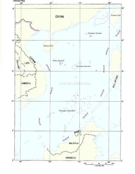
Archivo: China's 2009 nine-dash line map submission to the UN.pdf
Tamaño de esta previsualización JPG del archivo PDF: 463 × 599 píxeles. Otra resolución: 185 × 240 píxeles.
Archivo original (1275 × 1650 píxeles; tamaño de archivo: 412 KB; tipo MIME: application/pdf)
Descripción: Document “CML/17/2009” May 7, 2009, submitted by the People's Republic of China to the United Nations Commission on the Limits of the Continental Shelf. The map here is the second page in a two-page document. The first page is a text addressed to the UN Secretary General, noting China's sovereignty claim to the "islands in the South China Sea and the adjacent waters", however, the document remains ambiguous by being silent as to the precise meaning of the map enclosed, and the meaning of the nine-dash line on it
Términos de Uso: Dominio Público
Usos del archivo
La siguiente página enlaza a este archivo:

Todo el contenido de los artículos de la Enciclopedia Kiddle (incluidas las imágenes) se puede utilizar libremente para fines personales y educativos bajo la licencia Atribución-CompartirIgual a menos que se indique lo contrario.