
Archivo: Chile-Chonos Archipelago
Tamaño de esta previsualización: 485 × 600 píxeles. Otras resoluciones: 194 × 240 píxeles | 1032 × 1276 píxeles.
Archivo original (1032 × 1276 píxeles; tamaño de archivo: 572 KB; tipo MIME: image/jpeg)
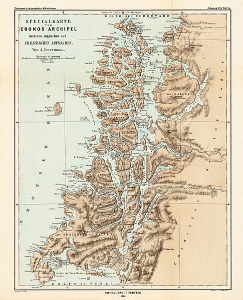
Descripción: Lithograph, printed in colors when published. Detailled map, showing the Chonos Archipel from the gulf of Penas with the Peninsula de Taytao up to the gulf of Corcovado. Very detailled map with an enormous number of islands and peninsulas, most of them with place names. The map provides an overview of the results of the travel by Th. von Heugelin to Somalia. It is also ornated with a scene of birds and mammals, which were discovered by Th. Heugelin in Somalia.
Título: Chile-Chonos Archipelago
Créditos: http://www.bergbook.com/htdocs/woda/data/demo/descriptions/17333.htm
Autor(a): Petermann, A.
Términos de Uso: Dominio Público
Licencia: Dominio Público
¿Se exige la atribución?: No
Usos del archivo
Las siguientes páginas enlazan a este archivo:

Todo el contenido de los artículos de la Enciclopedia Kiddle (incluidas las imágenes) se puede utilizar libremente para fines personales y educativos bajo la licencia Atribución-CompartirIgual a menos que se indique lo contrario.