
Archivo: Chicxulub

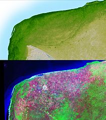
Descripción: The top picture is a shaded relief image of the northwest corner of Mexico's Yucatan Peninsula generated from Shuttle Radar Topography Mission (SRTM) data, and shows a subtle, but unmistakable, indication of the Chicxulub impact crater. Most scientists now agree that this impact was the cause of the Cretatious-Tertiary Extinction, the event 65 million years ago that marked the sudden extinction of the dinosaurs as well as the majority of life on Earth. The pattern of the crater's rim is marked by a trough, the darker green semicircular line near the center of the picture. The bottom picture is the same area viewed by the Landsat satellite, and was made by displaying the Thematic Mapper's Band 7 (mid-infrared), Band 4 (near-infrared) and Band 2 (green) as red, green and blue. These colors were chosen to maximize the contrast between different vegetation and land cover types, with native vegetation and cultivated land showing as green, yellow and magenta, and urban areas as white. The circular white area near the center of the image is Merida, a city of about 720,000 population. Notice that in the SRTM image, which shows only topography, the city is not visible, while in the Landsat image, which does not show elevations, the trough is not visible.
Título: Chicxulub
Créditos: http://photojournal.jpl.nasa.gov/catalog/PIA03381
Autor(a): Shuttle Radar Topography Mission
Permiso: 'Unless otherwise noted, images and video on JPL public web sites (public sites ending with a jpl.nasa.gov address) may be used for any purpose without prior permission [...] [1]
Términos de Uso: Dominio Público
Licencia: Dominio Público
¿Se exige la atribución?: No
Usos del archivo
La siguiente página enlaza a este archivo:
