
Archivo: ChicoClosedBasin

Tamaño de esta previsualización: 800 × 534 píxeles. Otras resoluciones: 320 × 213 píxeles | 832 × 555 píxeles.
Archivo original (832 × 555 píxeles; tamaño de archivo: 181 KB; tipo MIME: image/jpeg)
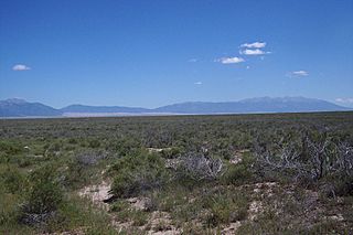
Description: Typical greasewood and rabbitbrush "chico" vegetation in the Closed Basin of the northern San Luis Valley in Colorado. Taken just south of the bridge over La Garita Creek on Highway 17 between Hooper and Moffat Colorado. View is to the southeast. The Great Sand Dunes are in the background as are the Sangre De Cristo Mountains.
Title: ChicoClosedBasin
Credit: Own work
Author: Fred Bauder
Usage Terms: Creative Commons Attribution-Share Alike 3.0
License: CC-BY-SA-3.0
License Link: http://creativecommons.org/licenses/by-sa/3.0/
Attribution Required?: Yes
Usos del archivo
La siguiente página enlaza a este archivo:

Todo el contenido de los artículos de la Enciclopedia Kiddle (incluidas las imágenes) se puede utilizar libremente para fines personales y educativos bajo la licencia Atribución-CompartirIgual a menos que se indique lo contrario.