
Archivo: Chera kingdom chieftaincies and Chola mandalams c 11th century-es

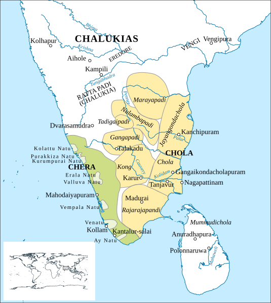
Descripción: * Medieval south India: chieftaincies in Chera kingdom and Chola mandalams Based on the map provided by Noboru Karishma (who credits Y. Subbarayalu) in A Concise History of South India (2014). Some elements missing from Karashima's map have been sourced from Subbarayalu's book directly. The spellings are as per Karashima (2014).Neither of the sources noted above explicitly date the map (to the 11th century). But the map is displayed in the context of the establishment of the Chola mandalams in the reigns of Raja Raja Chola (r. c. 985 – c. 1014 CE) and Rajendra Chola (r. c. 1014 – c. 1044 CE).Another version of the same chapter hosted on academia.edu by a JNU academic provides the caption, "Chieftaincies in the Chera Kingdom and the Chola-mandalams, ca. 1100" for an almost identical map. Chola provinces (mandalams) Chera kingdom Chieftaincies in Chera kingdom
Título: Chera kingdom chieftaincies and Chola mandalams c 11th century-es
Créditos: Trabajo propio, basado en: Chera kingdom, chieftaincies, and Chola mandalams c. 11th century.svg Projection: EPSG: 4044 Rivers, sea, lakes: Natural Earth Location of cities/towns: OSM & Wikipedia (mostly)
Autor(a): Cpt.a.haddock, Rowanwindwhistler
Términos de Uso: Creative Commons Attribution-Share Alike 4.0
Licencia: CC BY-SA 4.0
Enlace de Licencia: https://creativecommons.org/licenses/by-sa/4.0
¿Se exige la atribución?: Sí
Usos del archivo
La siguiente página enlaza a este archivo:
