
Archivo: Châteaux de la Loire - Karte
Descripción: This map results from a map request to the Kartenwünsche in the Kartenwerkstatt. You can make as well a request for a new map.
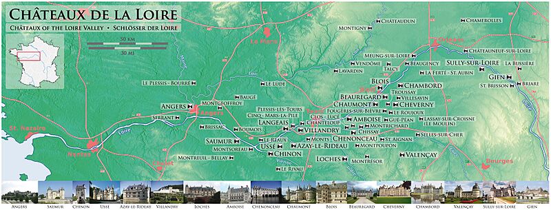
Título: Châteaux de la Loire - Karte
Créditos: Trabajo propio Using maps-for-free.com for the topographic background, this map for the orientation map of France, and this sign as draft for the motorway numberings. The sources of the images of the Châteaux are: Amboise, Angers, Azay-le-Rideau, Beauregard, Blois, Chambord, Chaumont, Chennonceau, Cheverny, Chinon, Gien, Loches, Saumur, Sully-sur-Loire, Ussé, Valençay, Villandry.
Autor(a): Maximilian Dörrbecker (Chumwa)
Permiso: Yo, el titular de los derechos de autor de esta obra, la publico en los términos de la siguiente licencia:
Términos de Uso: Creative Commons Attribution-Share Alike 2.5
Licencia: CC BY-SA 2.5
Enlace de Licencia: https://creativecommons.org/licenses/by-sa/2.5
¿Se exige la atribución?: Sí
Usos del archivo
No hay páginas que enlacen a esta imagen.
