
Archivo: Central Tien Shan, China
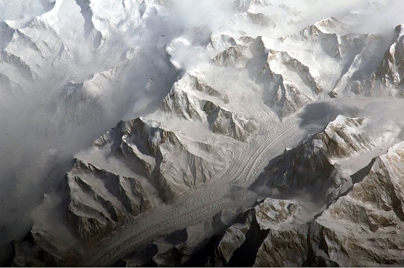
Descripción: This astronaut photograph provides a view of the central Tien Shan, about 64 kilometres east of where the borders of China, Kyrgyzstan, and Kazakhstan meet. While the image looks like it might have been taken from an airplane, it was taken from the International Space Station (ISS) at an altitude of 341 kilometres. The altitude plus the horizontal distance from the site—ISS was approximately 304 kilometres to the south-west—produces an oblique view. This angle, together with shadowing of valleys, accentuates the mountainous topography. Two types of glaciers are visible in the image; cirque glaciers occupy amphitheater-like depressions on the upper slopes of the mountains, and feed ice down-slope to aggregate into large valley glaciers such as the one at image centre. Low clouds obscure an adjacent valley and glaciers to the north (upper left). Two high peaks of the central Tien Shan are identifiable in the image. Xuelian Feng has a summit of 6, 527 meters above sea level. To the east, the aptly-named Peak 6231 has a summit 6,231 meters above sea level.
Título: Central Tien Shan, China
Créditos: NASA Earth Observatory
Autor(a): ISS Expedition 27 crew
Términos de Uso: Dominio Público
Licencia: Dominio Público
¿Se exige la atribución?: No
Usos del archivo
Las siguientes páginas enlazan a este archivo:
