
Archivo: Carlisle aerial westward

Tamaño de esta previsualización: 800 × 600 píxeles. Otras resoluciones: 320 × 240 píxeles | 2272 × 1704 píxeles.
Archivo original (2272 × 1704 píxeles; tamaño de archivo: 1,78 MB; tipo MIME: image/jpeg)
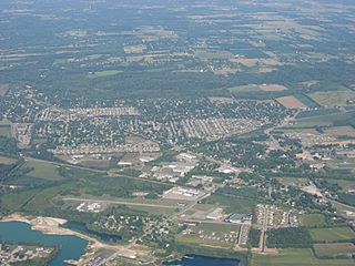
Description: Aerial view of Carlisle, a city split between Montgomery and Warren counties in the southeastern part of the U.S. state of Ohio. Picture taken from a Diamond Eclipse light airplane at an altitude of 4,540 feet MSL and a bearing of approximately 270º.
Title: Carlisle aerial westward
Credit: Own work
Author: Nyttend
Permission: I, the copyright holder of this work, release this work into the public domain. This applies worldwide. In some countries this may not be legally possible; if so: I grant anyone the right to use this work for any purpose, without any conditions, unless such conditions are required by law.
Usage Terms: Public domain
License: Public domain
Attribution Required?: No
Usos del archivo
La siguiente página enlaza a este archivo:

Todo el contenido de los artículos de la Enciclopedia Kiddle (incluidas las imágenes) se puede utilizar libremente para fines personales y educativos bajo la licencia Atribución-CompartirIgual a menos que se indique lo contrario.