
Archivo: California US Congressional District 23 (since 2013)

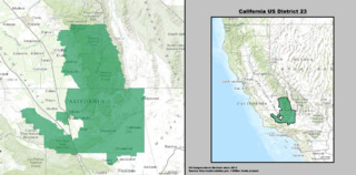
Description: Boundaries maps for California's 23rd US Federal Congressional District — primarily within Kern County and eastern Tulare County, central and southern California. Representing areas in the southern San Joaquin Valley, Southern Sierra Nevada, Tehachapi Mountains, and northwestern Mojave Desert. Sequoia National Park and Sequoia National Forest are within the district.
Title: California US Congressional District 23 (since 2013)
Credit: GIS shapefile data created by the United States Department of the Interior, as part of the "1 Million Scale" geospatial data project. Retrieved from: http://nationalatlas.gov/atlasftp-1m.html?openChapters=#chpbound
Author: 1: GIS (congressional districts, 2013) shapefile data was created by the United States Department of the Interior. 2: Data was rendered using ArcGIS® software by Esri. 3: File developed for use on Wikipedia and elsewhere by 7partparadigm.
Usage Terms: Public domain
License: Public domain
Attribution Required?: No
Usos del archivo
La siguiente página enlaza a este archivo:
