
Archivo: Battye freycinet swanriver lg
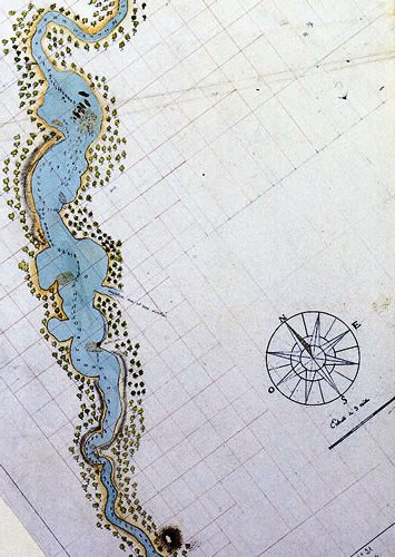
Description: Swan River Chart The first detailed map of the Swan River was drawn by François-Antoine Boniface Heirisson of the Naturaliste from direct observation after his journey by longboat along the Swan River from 17-22 June 1801. Heirisson has included on the chart soundings along the entire length of his journey, and comments on the singular topography of the mouth of the river (the bar) referring to features seen along its course.
Title: Battye freycinet swanriver lg
Credit: http://www.liswa.wa.gov.au/treasures/freycinet/swanriver.htm This image is a small section of the map at the Battye Library, from about today's Mosman Park to Ascot. The map seems to be somewhat out of scale, but most major features in the river can be recognised on the map. It is probable that upstream is up (as the map is oriented on the screen) and the Canning River entrance is midway along on the right hand side. Heirisson Island(s) are marked as dots midriver further up.
Author: François-Antoine Boniface Heirisson
Usage Terms: Public domain
License: Public domain
Attribution Required?: No
Usos del archivo
La siguiente página enlaza a este archivo:
