
Archivo: Angevin Empire 1190

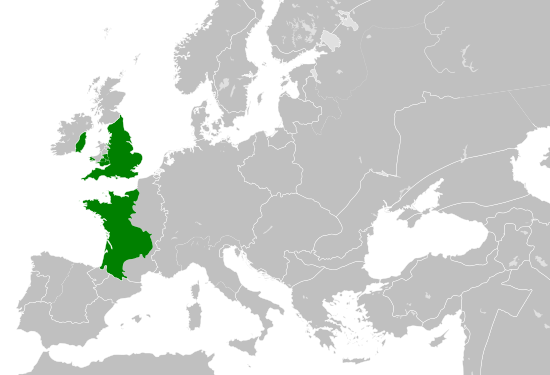
Descripción: A map of the so-called Angevin Empire within Europe circa 1190 CE, including possessions/vassals in France, Marcher Lordships in Wales and Barons in Ireland. Note that the borders of the Cumans, Kipchaks, Kievan Rus', Kama Bulgarians and Viatka do not extend right to the edge of the map (due to a sub-map covering them up on the source map). Also, Ireland was not united but was in fact composed of many petty kingdoms with a weak over-king.
Título: Angevin Empire 1190
Créditos: Este archivo deriva de: Blank map of Europe.svg: Primary data source: Europe mediterranean 1190.jpg
Autor(a): Blank map of Europe.svg: maixobra derivada: Alphathon
Términos de Uso: Creative Commons Attribution-Share Alike 4.0
Licencia: CC BY-SA 4.0
Enlace de Licencia: https://creativecommons.org/licenses/by-sa/4.0
¿Se exige la atribución?: Sí
Usos del archivo
La siguiente página enlaza a este archivo:
