
Archivo: Alabama US Congressional District 3 (since 2013)

Tamaño de esta previsualización JPG del archivo TIF: 800 × 411 píxeles. Otra resolución: 320 × 165 píxeles.
Archivo original (1964 × 1010 píxeles; tamaño de archivo: 3,32 MB; tipo MIME: image/tiff)
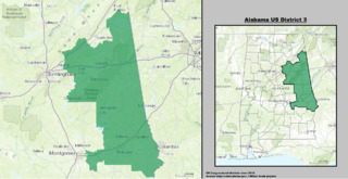
Description: Boundaries for Alabama’s 3rd United States Federal Congressional District.
Title: Alabama US Congressional District 3 (since 2013)
Credit: GIS shapefile data created by the United States Department of the Interior, as part of the "1 Million Scale" geospatial data project. Retrieved from: http://nationalatlas.gov/atlasftp-1m.html?openChapters=#chpbound
Author: 1: GIS (congressional districts, 2013) shapefile data was created by the United States Department of the Interior. 2: Data was rendered using ArcGIS® software by Esri. 3: File developed for use on Wikipedia and elsewhere by 7partparadigm.
Usage Terms: Public domain
License: Public domain
Attribution Required?: No
Usos del archivo
La siguiente página enlaza a este archivo:

Todo el contenido de los artículos de la Enciclopedia Kiddle (incluidas las imágenes) se puede utilizar libremente para fines personales y educativos bajo la licencia Atribución-CompartirIgual a menos que se indique lo contrario.