
Archivo: 20080929-laura-full
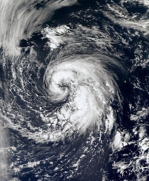
Descripción: In late September, a large non-tropical system located over the north-central Atlantic slowly moved westward away from the Azores. The low produced hurricane-force winds, but did not exhibit the characteristics of a tropical cyclone. The storm steadily weakened over the following days, but developed tropical characteristics as it moved over slightly warmer waters. By September 29, the low had developed sufficient convection and was declared Subtropical Storm Laura. Upon being upgraded, cold cloud tops began to wrap around the center of Laura and consolidate near the center of circulation. The convection organized around the center quickly and a satellite pass over the storm revealed that it could be intensifying. A later satellite pass disregarded the possibility of intensification as the intensity was confirmed to be at 60 mph (95 km/h). The overall structure of Laura remained subtropical but there were indications that it might have been acquiring tropical characteristics. As of 11 p.m. AST September 29 (0300 UTC September 30), Subtropical Storm Laura is located within 20 nautical miles of 38.3°N 48.4°W, about 585 mi (940 km) south-southeast of Cape Race, Newfoundland and Labrador. Maximum sustained winds are 50 knots (60 mph, 95 km/h), with stronger gusts. Minimum central pressure is 995 mbar (hPa; 29.38 InHg), and the system is moving north at 8 kt (9 mph, 15 km/h).
Título: 20080929-laura-full
Créditos: NASA Worldview
Autor(a): NASA
Permiso: Public domain
Términos de Uso: Dominio Público
Licencia: Dominio Público
¿Se exige la atribución?: No
Usos del archivo
Las siguientes páginas enlazan a este archivo:
