
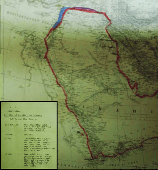
Archivo: 1918 British Government Map illustrating Territorial Negotiations between H.M.G. amd King Hussein
No disponible en mayor resolución.
1918_British_Government_Map_illustrating_Territorial_Negotiations_between_H.M.G._amd_King_Hussein.png (508 × 546 píxeles; tamaño de archivo: 489 KB; tipo MIME: image/png)
Description: MPK 1/410 extracted from FO 371/4368; (7) Larger printed map, showing additionally the whole Arabian peninsula. Reference table. Scale: 1:6,969,600. Ms additions, coloured, mark several areas under discussion. Title affixed: 'Map illustrating Territorial Negotiations between H.M.G. amd King Hussein'; reference table to additions affixed.
Title: 1918 British Government Map illustrating Territorial Negotiations between H.M.G. amd King Hussein
Credit: National Archives: http://discovery.nationalarchives.gov.uk/details/r/C3980431
Author: UK Government
Usage Terms: Public domain
License: Public domain
Attribution Required?: No
Usos del archivo
El siguiente archivo es un duplicado de éste (más detalles):
No hay páginas que enlacen a esta imagen.

Todo el contenido de los artículos de la Enciclopedia Kiddle (incluidas las imágenes) se puede utilizar libremente para fines personales y educativos bajo la licencia Atribución-CompartirIgual a menos que se indique lo contrario.