
Archivo: 1818 Pinkerton Map of of La Plata (Southern South America, Argentina, Chile, Bolivia) - Geographicus - LaPlata-pinkerton-1818
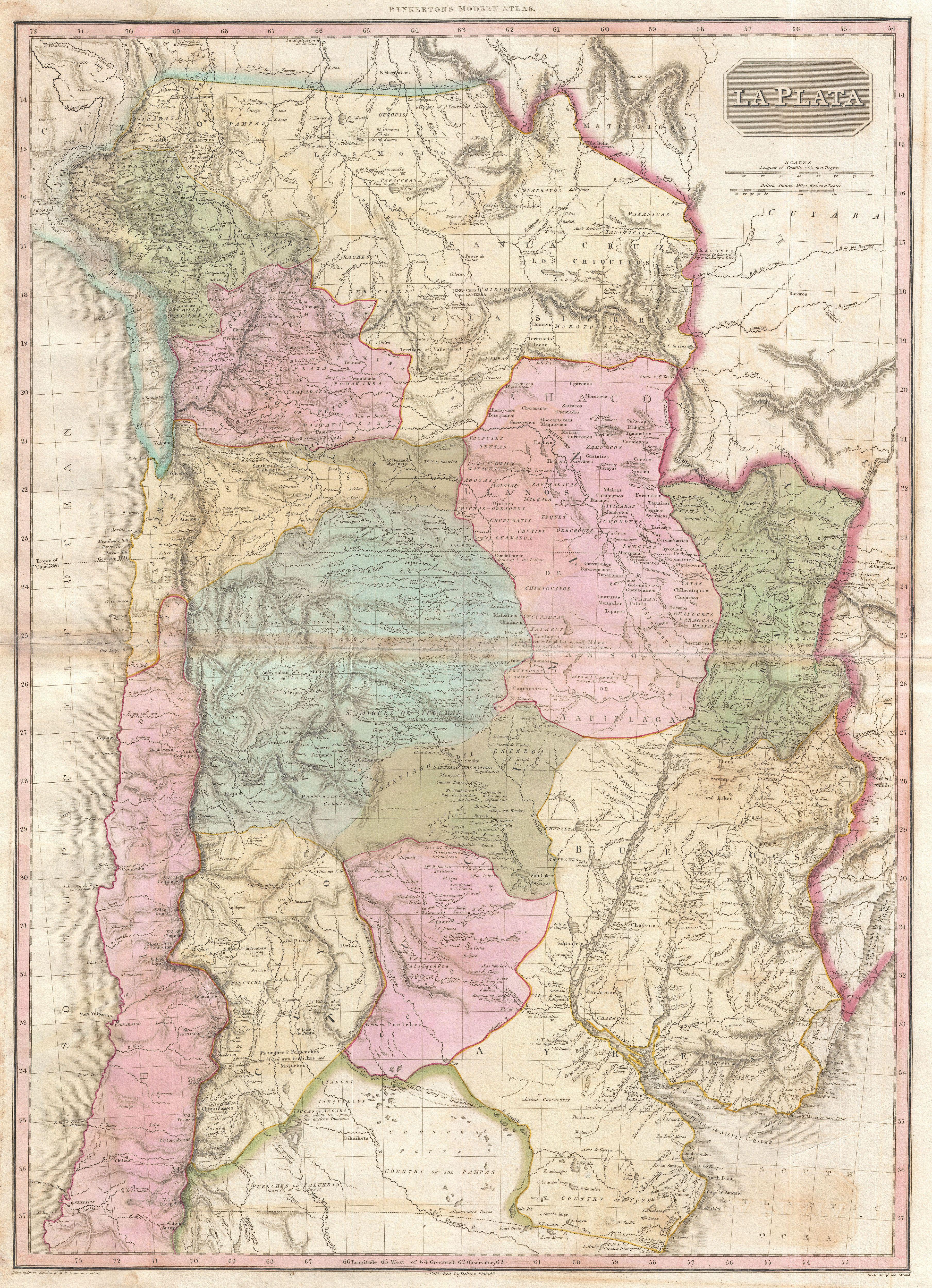
Descripción: An altogether extraordinary 1818 map of the southern parts of South America by John Pinkerton. Covers the modern day countries of Argentina, Bolivia, Paraguay, Chile as well as parts of adjacent Brazil and Peru. Pinkerton offers impressive detail throughout noting indigenous groups, missions, towns and cities, swamps, mountains, and river systems. Upper left hand quadrant features the title plate and two distance scales, one in British Miles and the other in Castile Leagues. Cartographically speaking this is an often neglected part of the world - especially in the early 19th century. Though the coastlands and open plains had been well mapped early in the 16th century, the interior was rarely penetrated. The combination of mountainous terrain, daunting jungles, malaria, and unfriendly indigenous groups combine to make this area all but unexplorable - even today. Nonetheless, Pinkerton make a commendable attempt to piece together early conquistador accounts, explorer's journals, missionary records, and indigenous reports into a coherent mapping of the area. In doing so he achieves a number of significant advances in the mapping of the region. In general, this map reads like a litany of disappointment. The number if ruined towns, abandoned missions, forgotten mines, and destroyed settlements would be hard to match in any other map. Pinkerton notes the ruins of La Conception, St. Isabel, Santa Cruz de la Sierra, and Guadalcazar to name but a few. In the Andes, he identifies the sites of a number of important mountains and volcanoes including Aconcagua, Coquimbo, Petoroa, and others. He also identifies the site of the majestic ruined pre-Columbian city on the shores of Lake Titicaca. Traditionally cartographers identified the apocryphal Lake of Xarayes as the source of the Paraguay River. In earlier days, explores associated this lake with legends of Paradise, El Dorado, and the gateway to the Amazon. The lake itself, though never existed. Instead it was a misinterpretation of the vast Pantanal flood plain during the rainy season. Here Pinkerton abandons the notation of a Lakes of Xarayes, instead identifying numerous Lakes of Xarayes, and in doing so come much closer to the truth. This is the first map to exhibit this change which is itself a significant advance the mapping of the Amazon Basin. Drawn by L. Herbert and engraved by Samuel Neele under the direction of John Pinkerton. This map comes from the scarce American edition of Pinkerton’s Modern Atlas, published by Thomas Dobson & Co. of Philadelphia in 1818.
Título: La Plata.
Créditos: This file was provided to Wikimedia Commons by Geographicus Rare Antique Maps, a specialist dealer in rare maps and other cartography of the 15th, 16th, 17th, 18th and 19th centuries, as part of a cooperation project.
Autor(a): John Pinkerton
Permiso: Esta es una reproducción fotográfica fiel de una obra de arte bidimensional de dominio público. La obra de arte misma se halla en el dominio público por el motivo siguiente: Public domainPublic domainfalsefalse Este material está en dominio público en los demás países donde el derecho de autor se extiende por 100 años (o menos) tras la muerte del autor. También debes incluir una etiqueta de dominio público de los Estados Unidos para indicar por qué esta obra está en el dominio público en los Estados Unidos. Esta obra ha sido identificada como libre de las restricciones conocidas en virtud del derecho de autor, incluyendo todos los derechos conexos. https://creativecommons.org/publicdomain/mark/1.0/PDMCreative Commons Public Domain Mark 1.0falsefalse La postura oficial de la Fundación Wikimedia considera que «las reproducciones fieles de obras de arte bidimensionales de dominio público forman parte del dominio público». Esta reproducción fotográfica, por ende, también se considera de dominio público dentro de los Estados Unidos. Es posible que otras jurisdicciones restrinjan la reutilización de este contenido; consúltese Reutilización de fotografías PD-Art (en inglés) para más detalles.
Términos de Uso: Dominio Público
Licencia: Dominio Público
¿Se exige la atribución?: No
Usos del archivo
La siguiente página enlaza a este archivo:
_-_Geographicus_-_LaPlata-pinkerton-1818.jpg&oldid=2972064)

_-_Geographicus_-_LaPlata-pinkerton-1818.jpg)