
Archivo: 1811 Humboldt Map of Mexico, Texas, Louisiana, and Florida - Geographicus - Mexique-humboldt-1811
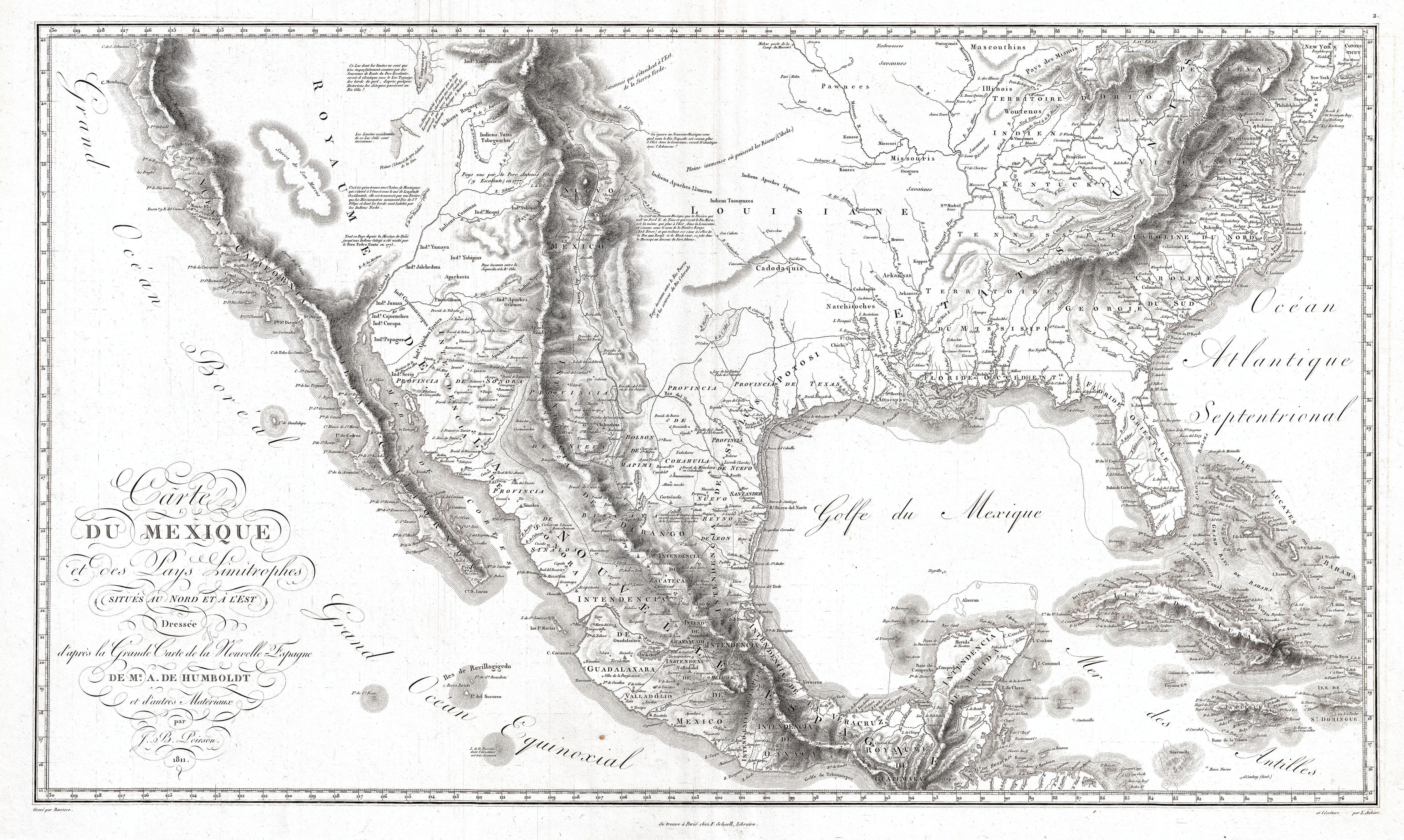
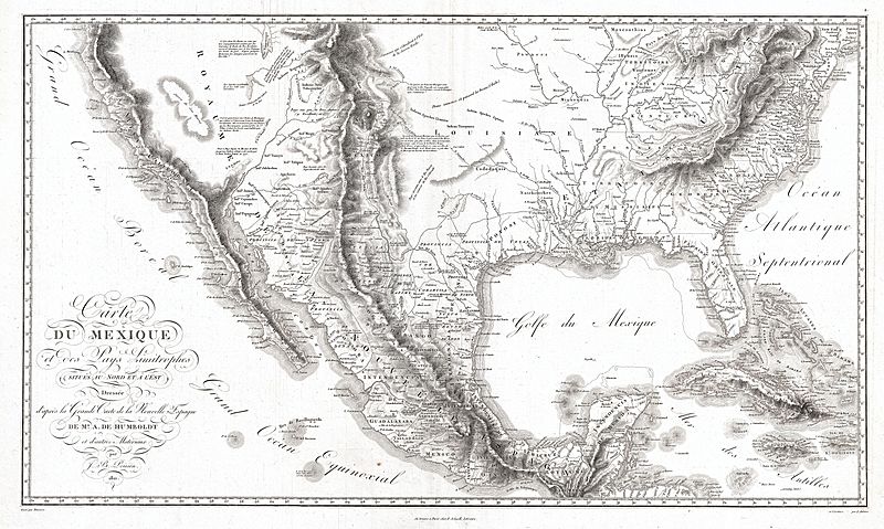
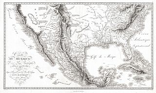
Descripción: A seminal 1811 map of the Spanish colonial Viceroyalty of New Spain in North America (present day Mexico and the American West), and the Southern U.S., by Alexander von Humboldt. History Humboldt, who during his lifetime was considered the world's greatest living man, composed this map during his 1803 sojourn in New Spain (Mexico). Though often playing second fiddle to Humboldt's more regional "Carte Generale du Royaume de la Nouvelle Espagne", published in the same volume, this map is a cartographic achievement in its own right and, as Wheat notes "An Important Map." Covering from Alta California to Connecticut and from the Great Salt Lake (here Timpanagos) to Honduras, this extraordinary map not only includes most of the important cartographic innovations introduced in Carte Generale du Royaume de la Nouvelle Espagne , it also frames this information in context with much of the territory that in the coming years would be subsumed into the expanding United States. Humboldt spent part of 1803 and 1804 living in Mexico City as a guest of the Spanish Crown. As such he had access to rarely seen explorer's accounts and earlier mappings available in the Mexico City archives. These he combined with information from his own travels and explorations, as well as indigenous cartographic traditions and his own theoretical understanding of geography, to create this landmark mapping of the North American southwest - the most sophisticated and advanced treatment of the region yet seen.Advancements Among the significant advancements apparent on this map are Humboldt's connection of Fiedler and Mackenzie's Stoney Mountains, today the Rocky Mountains, with the Cordilleras of Mexico. Humboldt also correctly maps the course of the Rio Gila as is passes north and west of Tubscon (Tuscon). To the east of the Rocky Mountains, a burst of remarkable insight enables Humboldt to correctly unite the Nepeste and Arkansas Rivers. The Great Plains Humboldt curiously associates with Cibola, one of the seven legendary cities of gold, but in actuality a former Hopi settlement in modern day New Mexico. Humboldt was a great fan in indigenous cartographic knowledge, which he incorporates here with regard to the Aztec migration myth of Lake Teguayo - which he associates with Lake Timpanagos or Great Salt Lake. The is a common though likely erroneous connection which Humboldt was not the first to make. For the remainder of the map Humboldt draws on a number of sources including the Meria-Escalante expedition (west of the Rocky Mountains), accounts of the voyages of the ships Sutil, and Mexicana (Pacific Coast), the memoir of M. Espinsoa (Pacific Coast), the Lafond map (Louisiana), and the Arrowsmith map (United States). Humboldt's extraordinary cartographic work would remain the authorities document on this region until advanced by the expeditions of Fremont, himself an acknowledged Humboldtian, in the late 1840s.After For his efforts Humboldt was awarded with honorary Mexican citizenship, which he retained until his death at 87. However, had the Mexican officials who applauded Humboldt seen how his mappings would influence the future shape of their nation, they may have been less than pleased. In May of 1804, Humboldt sailed into Philadelphia. There he befriended Jefferson, Madison, Peale, and other post-colonial American luminaries. Believing in the free and open exchange of scientific data, Humboldt freely shared manuscript copies of his mappings of the American southwest. Shortly before the official 1811 publication of Humboldt's important maps, the priest Hildago shouted the historic 1810 Grito de la Independencia , beginning the Mexican War of Independence. The events that followed led directly to the 1830s Texas Revolution and the 1840s Mexican American War. Humboldt's masterful mappings of the region - of which this is one - gave the United States crucial intelligence that would eventually lead to the U.S. expansion.
Título: Carte Du Mexique et des Pays Limitrophes Situes Au Nord et a l'est Dressee d'apres la Grande Carte de la Nouvelle Espagne De Mr. A. De Humboldt et d'autres Materiaux par J.B. Poirson.
Créditos: This file was provided to Wikimedia Commons by Geographicus Rare Antique Maps, a specialist dealer in rare maps and other cartography of the 15th, 16th, 17th, 18th and 19th centuries, as part of a cooperation project.
Autor(a): Alexander von Humboldt
Permiso: Esta es una reproducción fotográfica fiel de una obra de arte bidimensional de dominio público. La obra de arte misma se halla en el dominio público por el motivo siguiente: Public domainPublic domainfalsefalse Este material está en dominio público en los demás países donde el derecho de autor se extiende por 100 años (o menos) tras la muerte del autor. También debes incluir una etiqueta de dominio público de los Estados Unidos para indicar por qué esta obra está en el dominio público en los Estados Unidos. Esta obra ha sido identificada como libre de las restricciones conocidas en virtud del derecho de autor, incluyendo todos los derechos conexos. https://creativecommons.org/publicdomain/mark/1.0/PDMCreative Commons Public Domain Mark 1.0falsefalse La postura oficial de la Fundación Wikimedia considera que «las reproducciones fieles de obras de arte bidimensionales de dominio público forman parte del dominio público». Esta reproducción fotográfica, por ende, también se considera de dominio público dentro de los Estados Unidos. Es posible que otras jurisdicciones restrinjan la reutilización de este contenido; consúltese Reutilización de fotografías PD-Art (en inglés) para más detalles.
Términos de Uso: Dominio Público
Licencia: Dominio Público
¿Se exige la atribución?: No
Usos del archivo
Las siguientes páginas enlazan a este archivo:
