
Archivo: 1730 C. Homann Map of Asia - Geographicus - Asiae-homann-1730
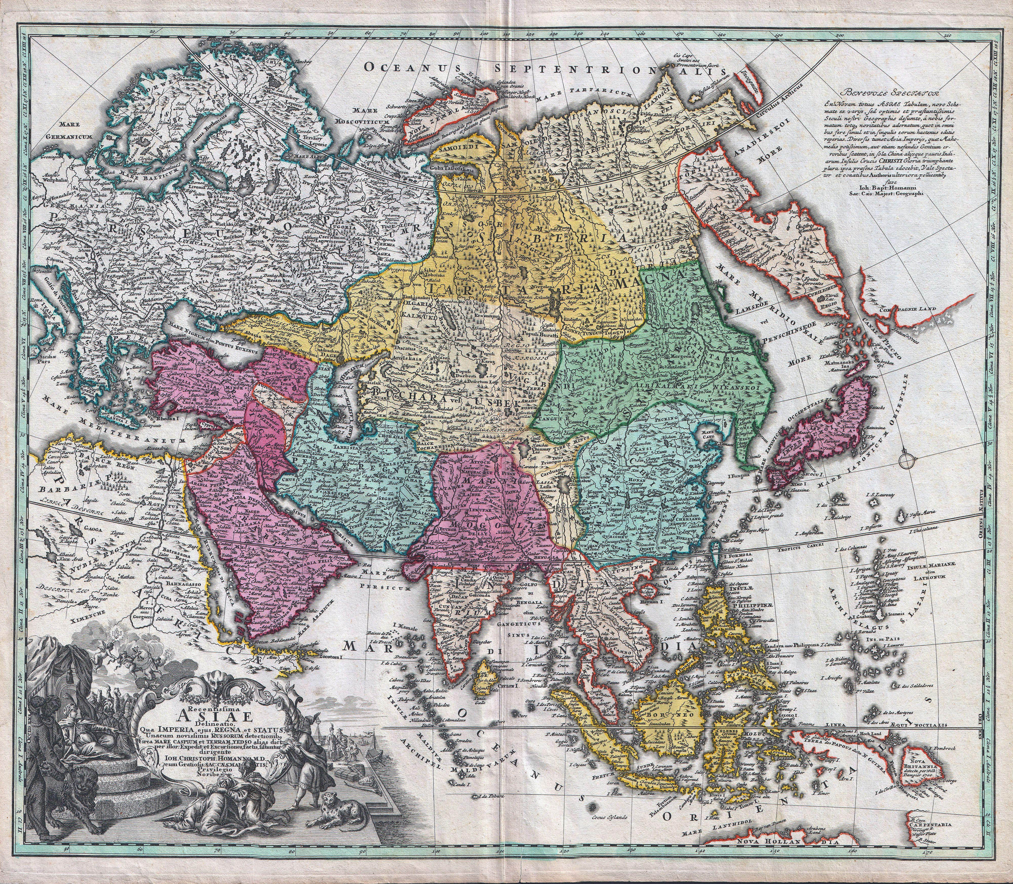
Descripción: A rare and attractive 18th century map of Asia by German map publisher Johann Christoph Homann. Covers the entire continent of Asia as well as parts of Europe and northeastern Africa. This is essentially a revised and updated version of J. B. Homann’s 1712 map of Asia. Features some interesting and important updates. Most notably, we see the addition of the Kamchatka Peninsula in the upper right hand quadrant. The lower part of the peninsula is labeled “Kurilorum Regio”, no doubt an early reference to the Kuril Islands. While Hokkaido is not present, Japan itself is separated from the mainland by a small archipelago. Just east of these islands we see the Canal de Piecko, and beyond that a large and curious land mass labeled Compagnie Land. Compagnie Land is a mythical landmass that can be traced the work of an unknown Spanish pilot who supposedly traveled from China to New Span and published his finding along with the works of Thevenot. Present in both the 1712 map and this one, Compagnie’s Land could possibly be an early representation of Alaska or a misrepresentation of Hokkaido. Korea or Corea is present if misshapen in roughly the correct location. Further south New Guinea, New Britannia, Australia (New Holland), Hoch Land, and Carpentaria (part of Australia) are personated in tentative form with largely unexplored boundaries. At the center of the map the Caspian Sea is displayed according to the 1722 surveys of Karl van Verden. Bottom left quadrant features a decorative title cartouche displaying an enthroned king in Middle Eastern or Indian garb, exotic animals including a lion and leopard, trade goods, Camels, and bowing supplicants. A spectacular and important 18th century map of Asia.
Título: Recentissima Asiae Delineatio : Qua Imperia, eius Regna, et Status, Unacum novissimis Russorum detectionibus circa Mare Caspium et Terram Yedso alias dict. per illor. Expedit. et Excursiones, factis sistuntur.
Créditos: This file was provided to Wikimedia Commons by Geographicus Rare Antique Maps, a specialist dealer in rare maps and other cartography of the 15th, 16th, 17th, 18th and 19th centuries, as part of a cooperation project.
Autor(a): Johann Christoph Homann
Permiso: Esta es una reproducción fotográfica fiel de una obra de arte bidimensional de dominio público. La obra de arte misma se halla en el dominio público por el motivo siguiente: Public domainPublic domainfalsefalse Este material está en dominio público en los demás países donde el derecho de autor se extiende por 100 años (o menos) tras la muerte del autor. También debes incluir una etiqueta de dominio público de los Estados Unidos para indicar por qué esta obra está en el dominio público en los Estados Unidos. Esta obra ha sido identificada como libre de las restricciones conocidas en virtud del derecho de autor, incluyendo todos los derechos conexos. https://creativecommons.org/publicdomain/mark/1.0/PDMCreative Commons Public Domain Mark 1.0falsefalse La postura oficial de la Fundación Wikimedia considera que «las reproducciones fieles de obras de arte bidimensionales de dominio público forman parte del dominio público». Esta reproducción fotográfica, por ende, también se considera de dominio público dentro de los Estados Unidos. Es posible que otras jurisdicciones restrinjan la reutilización de este contenido; consúltese Reutilización de fotografías PD-Art (en inglés) para más detalles.
Términos de Uso: Dominio Público
Licencia: Dominio Público
¿Se exige la atribución?: No
Usos del archivo
La siguiente página enlaza a este archivo:
