
Archivo: 1696 Danckerts Map of Florida, the West Indies, and the Caribbean - Geographicus - WestIndies-dankerts-1696

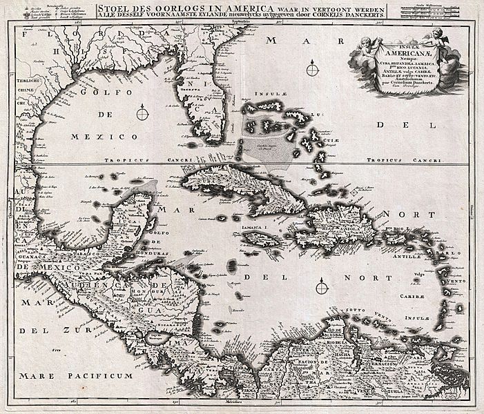
Descripción: An absolutely stunning example of Cornelius Danckerts' important 1696 map of Florida, the West Indies, Central America, the Caribbean, and the Spanish Main. Cartographically influenced by Blaeu's 1636 map of the same region, this map covers from Mexico to the Antilles and from Florida to the Spanish Main, inclusive of Cuba, the Bahamas, Hispaniola, Jamaica, Porto Rico, and the Lesser Antilles. The detail throughout is spectacular with missions, forts, cities, ports, rivers, lakes, indigenous groups, and an assortment of additional topographical details noted. Florida is labeled as the province of Tegesta, following the convention established by Dutch cartographers Johannes de Laet and Hessel Gerritzoon in 1630. The Tegesta were an indigenous tribe active in the southeastern parts of Florida, around what is today Miami-Dade. They were encountered in the 16th century by Ponce de Leon and by one of the ships commanded by Pedro Menéndez de Avilés. Though largely subject to the more powerful tribes of western Florida, the Tegesta were among the first of Florida's indigenous groups to encounter Europeans and subsequently influenced the naming of Florida for some 200 years. Curiously, despite several expeditions and interesting earlier maps of Florida, Dankerts has chosen to leave the interior blank, noting neither the Everglades nor any of Florida's great lakes. The interesting cartographic decision to discard all previous mappings of the Florida region contrasts strikingly with the remainder of the map, which is lavishly and often speculative detailed. Following the western coast of Florida north, along the Gulf and then west towards Texas and Mexico, we can begin to see just how little was known of the Gulf Coast despite nearly 200 years of European activity in the region. The Mississippi River is entirely absent, though a great fan shaped river system does radiate northward from the Bay of Spiritu Santo (today most commonly associated with Galveston Bay). Looking northward and inland from the Gulf Coast, a number of communities appear in reference to various indigenous groups encountered by the De Soto and Coronado expeditions - these include the Chicasa, the Talacasa (whose warriors nearly overwhelmed and slaughtered De Soto's army), and Achusi. The West India Islands, centered on Cuba, are mapped with considerable accuracy though universally distorted on the north-south axis. The Bahamas are vaguely and inaccurately mapped throughout, though some attempt has been made to depict the undersea Bahama Bank. San Salvador or Guanahani, the supposed island where Columbus is said to have first landed in the New World, is noted. Central America, which sweeps diagonally across the lower left quadrant of the map is strikingly accurate with the exception of a distorted Yucatan - which here appears almost like an inversion of a similarly distorted Florida just to the northeast. Both Lake Nicaragua and the adjacent Lake Managua are noted, but are situated on an east-west rather than the correct north-south axis. Along the Spanish Main the great trading cities of Cartagena, Venezuela, and Valentia are noted, ss are a number of missions and indigenous centers in the interior. Maracaibo Bay is entirely misrepresented. Further east, Dankerts attempts to illustrate the countless islands of the Orinoco Delta. A title cartouche including two cherubs appears in the upper right quadrant. A key to the map's symbols, three distance scales, and an secondary Dutch description of the map appears above the map's printed border. The description declares that this map was made to illustrate the theater of war in the West Indies. The war in question is most likely the Nine Years' War (1688–97), fought between France and England over control of the New World.
Título: Insulae Americanae, Nempe: Cuba, Hispaniola, Jamaica, Pto Rico, Lucania, Antillae vulgo Caribae, Barlo -Et Sotto - Vento. Etc.
Créditos: This file was provided to Wikimedia Commons by Geographicus Rare Antique Maps, a specialist dealer in rare maps and other cartography of the 15th, 16th, 17th, 18th and 19th centuries, as part of a cooperation project.
Autor(a): http://www.geographicus.com/mm5/cartographers/dankerts.txt
Permiso: Esta es una reproducción fotográfica fiel de una obra de arte bidimensional de dominio público. La obra de arte misma se halla en el dominio público por el motivo siguiente: Public domainPublic domainfalsefalse Este material está en dominio público en los demás países donde el derecho de autor se extiende por 100 años (o menos) tras la muerte del autor. También debes incluir una etiqueta de dominio público de los Estados Unidos para indicar por qué esta obra está en el dominio público en los Estados Unidos. Esta obra ha sido identificada como libre de las restricciones conocidas en virtud del derecho de autor, incluyendo todos los derechos conexos. https://creativecommons.org/publicdomain/mark/1.0/PDMCreative Commons Public Domain Mark 1.0falsefalse La postura oficial de la Fundación Wikimedia considera que «las reproducciones fieles de obras de arte bidimensionales de dominio público forman parte del dominio público». Esta reproducción fotográfica, por ende, también se considera de dominio público dentro de los Estados Unidos. Es posible que otras jurisdicciones restrinjan la reutilización de este contenido; consúltese Reutilización de fotografías PD-Art (en inglés) para más detalles.
Términos de Uso: Dominio Público
Licencia: Dominio Público
¿Se exige la atribución?: No
Usos del archivo
La siguiente página enlaza a este archivo:
